
Summary
The Arid Hydrology and Water Systems program primarily focuses on developing resilient water management practices while considering present and projected future water demands and supplies in Far West Texas.
Dr. Palmate’s research addresses issues arising from climate change, land use/cover change, and different management practices on the water balances and hydrologic components in arid and semi-arid regions of the Southwestern United States.
We focus on hydrology in arid regions, and transboundary water resources planning and management. To accomplish this vision, we are committed to
- Excellence in technical research and professional services for the assessment of surface water and groundwater availability
- Using innovative science-based solutions for integrated water resources management
- Encouraging professional development for graduate students and post-doctoral research associates and cooperative partnerships with regional stakeholders, national and international agencies and institutes.
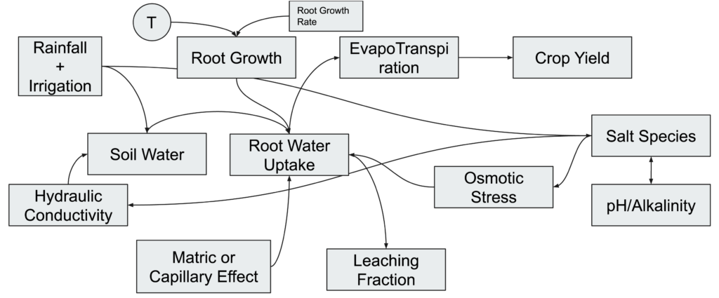
Water-Salt-Agriculture System Dynamic Modeling
System dynamics modeling is designed to enable decision making. It starts with a system diagram for the complex non-linear system under investigation. The dynamic behavior of interacting systems may be simulated by mathematically representing the flows from key stocks (reservoirs) in the system diagram and interactions between stocks.
This project aims to better represent the complex interactions for the water-salt-agriculture linked system and enable decision making for enhancing the overall sustainability of irrigated agriculture in the arid region. This modeling will directly aid growers to assess the varying impacts of salt in irrigation water on soil and crops.
Complex linkages that describe the interactions between irrigation water, soils, and crops. A key stock here is water that runs off, seeps in the soil, leaches out of the root-zone, or is consumed by the crops. The other key stock is the salt that is carried by the water and maybe deposited on the soil. Salt deposition changes the water flows and water flows affect the salt deposition. Together, the amount of salt and water applied influences the ability of crops to gainfully use water.
Remote Sensing to Assess Field-Scale Spatial Heterogeneity
Fields are not uniform. The heterogeneity in soil and salt-buildup has an impact on the overall yield and sustainability of farms. However, these heterogeneities are hard to describe for targeted interventions, numerical modeling, and ‘what-if’ type analysis. Aerial remote sensing (using drones) may provide a solution to get around this dilemma. We are developing new methods that use remotely sensed data products (e.g., surface temperatures) in combination with water-salt-agriculture system dynamic modeling to illustrate the spatial heterogeneity.
a) Simplified algorithm to convert observed surface temperature to evapotranspiration (key for predicting crop growth and stress), b) surface temperature observed from aerial remote sensing over a pecan orchard; the aircraft was flying 400ft over the orchard. c) surface temperature converted to evapotranspiration in mm/day.
Using Hydroinformatics for Enabling Actionable Decision Making
Sustainable Water Resources for Irrigated Agriculture in a Desert River Basin Facing Climate Change and Competing Demands
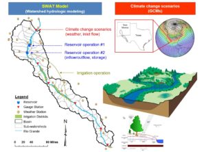
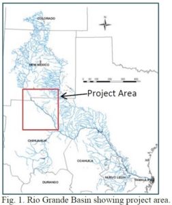 This project is funded by USDA-NIFA, led by Dr. William Hargrove of University of Texas at El Paso in collaboration with New Mexico State University, Universidad Autónoma de Ciudad Juarez (UACJ), Texas A&M University, Michigan Tech and University of New Mexico and working with regional stakeholders to gain a better understanding of future scenarios of water availability and use in the Rio Grand project area.
In spite of dwindling supplies, competing demands, and a changing climate, sufficient water supplies can be achieved and managed to sustain irrigated agriculture in the desert Southwest through innovative technologies, collaborative decision making, and improved policies. Critical components of this complex system include the changing climate which is a crucial driver of water supply and demand, the hydrological connections between surface and groundwater and finally the dynamic bi-national demand for water between the large metropolitan area of El Paso and Ciudad Juarez, the irrigated agricultural area upstream, downstream, and surrounded by the Chihuahuan desert. Using our improved characterization and understanding of the system to develop and test technologies and policies will augment useable water supplies, optimize the allocation of water to competing demands and improve water use efficiency, conservation, and environmental impacts.
Our approach will result in an improved understanding of both stakeholders and researchers of the drivers of water supply and demand. And present acceptable, workable, solutions at a local and regional level. We also plan to develop a dynamic and enduring systems model that can be consulted and adjusted. Ultimately, we want to create transferrable approaches and solutions aimed at the arid/semi-arid basins where irrigated agriculture faces challenges from climate change, competing demands, and salinization. This research will continue to strengthen our universities and research centers to train and develop water professionals.
Fact Sheets:
- Linking Hydrological Models for Watershed Management
- ET Tower Provides Information for Water Conservation
- Evaluation of Irrigation Efficiency Strategies for Far West Texas
- Coordinated Water Resources Databases & GIS for Watershed Management
- Development of RiverWare Model of the Rio Grande Flow for Flood Control and Water Operations Planning
- TAMU and NMSU Scientists Help Irrigation Districts in Water Conservation
Diversifying the Water Portfolio for Agriculture in the Rio Grande Basin
 This project is funded by USDA-NIFA, led by Dr. John Tracy, Director of the Texas Water Resources Institute, and in collaboration with New Mexico State University to explore alternative water sources to sustain agricultural production in the Rio Grande basin.
The long-term goal of this project is understanding how to optimize all available water resources in the Rio Grande Basin for the most significant return. Namely, sustaining agricultural production while enhancing regional water use efficacy, encouraging economic and employment opportunities, and improving ecosystem services.
We first evaluated the current water sources and then looked at the use of water in the following settings: urban, agricultural and the ecosystem. We took into account the changing climate, water management practices, and demographics. Through our research, we are demonstrating the appropriate use of saline and reclaimed water resources across agricultural, municipal and industrial environments and recommending revisions in cropping patterns and agricultural management practices. We are developing research and demonstration tools focused on improving the management of water at all scales (on-farm, M&I systems, canal operation, and irrigation district) within the Rio Grande Basin. Our goal is to identify the most economically efficient use of fresh and marginal water supplies to attain its highest social and agricultural value. Finally, it is essential to broaden outreach, demonstration, teaching, and tools to facilitate the efficient use of all available water resources for regional stakeholders. This research impacts the farmers and water managers in the Rio Grande Basin but will be relevant to similar watersheds in the Southwest United States and other arid regions around the world. We plan to reach out with our results to Regional Water Planning Groups, water managers, and the Extension service to continue knowledge sharing.
Fact Sheets:
- Hydrological Assessment of Salinity in the Pecos River
- Installation of Rio Grande Project Area Monitoring Network
- Rio Grande Salinity Management Preliminary Economic Impact Assessment
- Use of Reclaimed Effluent and Salty Groundwater for Cotton Production
- Water Conservation Through Reuse of Graywater
- Soil Salinity Management Using Synthetic Organic Polymer
Transboundary Aquifer Assessment Program – Regional Groundwater Availability Study
 The United States (US)-Mexico Transboundary Aquifer Assessment Program (TAAP) was established under the 2006 Act (Public Law 109-448) to develop and implement an integrated scientific approach to identify and assess priority transboundary aquifers. The overarching goal of TAAP is to produce scientific products for priority transboundary aquifers that—are capable of being broadly distributed and provide the scientific information needed by water managers and natural resource agencies on both sides of the United States-Mexico border to accomplish the missions of the managers and agencies effectively. Priority aquifers were named in the TAAP Act, and are the Hueco Bolson under Texas and Chihuahua Mexico, the Mesilla/Conejos-Médanos aquifer running underneath New Mexico and Chihuahua Mexico, and the San Pedro and Santa Cruz aquifers under the state of Arizona and Sonora, Mexico.
The USGS Water Science Centers (WSC) and the Water Resources Research Institutes (WRRI) of Texas, New Mexico, and Arizona have worked collaboratively and will continue to work collaboratively under TAAP to achieve common goals by capitalizing on the capabilities and expertise that each organization possesses. The U.S. and Mexican State Departments facilitate bilateral projects and collaboration with Mexican universities and federal agencies such as the National Water Commission. In 2016 TAAP was added as a Regional Groundwater Availability Study under the Water Availability and Use Science Program of USGS.
TAMU Team (John Tracy, Rosario Sanchez, and Zhuping Sheng) focus on the shared aquifers along the US-Mexico border within Texas, including Hueco Bolson and Mesilla Basin aquifers as identified in the original Act.
https://transboundary.tamu.edu/
Fact Sheets:
Managed Aquifer Recharge – Powerful Tool for Conjunctive Management of Water Resources
 TAMU Water Seed Grant: We are teaming with Dr. Gretchen Miller, Department of Civil Engineering of TAMU to develop better methods and guidance for determining the potential local and large scale effects of mixing native groundwater and introduced waters before ASR project development. We are working to demonstrate the impact of subsurface heterogeneity on ASR hydraulics and contaminant transport and providing recommendations on priorities for preliminary site investigation. As well as creating an operations/decision-making module to optimize energy use and enhance recovery fraction in ASR systems based on hydraulics and aquifer properties. This study includes case studies in El Paso and San Antonio in Texas and Belgium.
Harris County Flood Control District Drainage Reuse Initiative Feasibility Study (Phases I and II): investigate the feasibility of alternative methods of flood mitigation by conveying stormwater to the subsurface, including natural infiltration into underlying aquifer, enhanced infiltration or injection via drywell into unconfined aquifers and ASR wells into a deep formation.
Fact Sheets:
Dr. Santosh S. Palmate

Assistant Professor